Cumulative Distance: 684.8 (1,102.1 km)
Average Speed: 14.6 (23.5 kph)
Climb: 7,306 ft (2,226.8 m)
Cumulative Climb: 42,484 (12,949 m)
Flats: 0
Cumulative Flats: 5
Goodby Arizona, Hello New Mexico
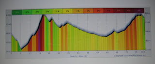
We exercised our high altitude climbing legs today with the hardest day of the trip. We started the day with a climb of over 2,500 ft in the Apache National Forest to an elevation of 6300 ft.
Then a 10 mile descent and a border crossing to New Mexico and into the Gila National Forest. Most of our day was above a mile high and our lunch stop was exactly 5,280 ft.
We were in beautiful mountain wilderness throughout the day with very little traffic. You can just see three of us approaching one of the switchbacks in the picture above. And in the one below, the picture was taken from the road farther up another switchback. Tough climbing!
Here is the profile of today's climb. Sorry it is a bit fuzzy but unusual manipulations were required to get it imported to the blog.
At our lunch spot a hitchhiker and his dog were heading in the opposite direction, with only a few shots at finding a ride. Shortly after lunch we met a one legged biker also going across the USA on the Southern Tier Route, but he was travelling from east to west. His wife is driving the support car. They were hoping to make it to Safford tonight but it was over 70 miles away so they are faced with a night of camping. Fortunately there are several campsites in the National Forests.
Late in the day, about four miles from Silver City, we crossed the continental divide at 6,230 ft and then downhill to our destination. Tomorrow we go higher - stay tuned!


No comments:
Post a Comment