Friday, April 9, 2010

Day 17: Camp Wood to Kerrville, TX

Distance: 88.3 mi (142.1 km)
Cumulative Distance: 1,490 (2,399 km)
Average Speed: 14.2 mph (22.9 kph)
Climb: 6,923 ft (2,110 m)
Cumulative Climb: 80,907 ft (24,660 m)
Flats: 0
Cumulative Flats: 11

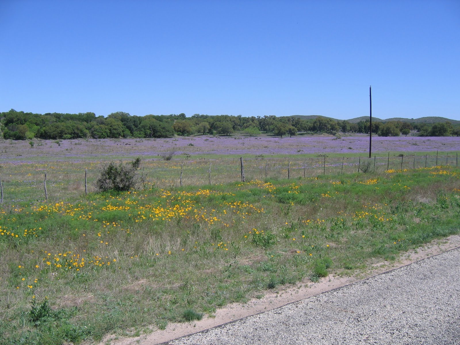
We experienced a tough day in the Texas Hill Country, with almost 7,000 feet of difficult climbing. The roads were a bit better, but still not great. The country is getting greener and the ranches more prosperous.


We have seen many carcasses (deer, coyotes, and even cattle) along the road. We saw a deer early in the day that had been killed last night. The vultures had not yet gotten at it, but they were starting their work. Many other carcasses we have seen have not been as pleasant. As we ride late in the day and the vultures begin to circle, we begin to joke about our ability to finish the day’s ride.


Midway through today’s ride we came upon a fence row with over a thousand boots on top of each fence post. Most were thoroughly worn cowboy boots.


The last quarter of today’s ride was along the Guadalupe River, which we crossed many times over road beds designed to flood during strong rains. Flood gauges along the roads showing depths to 8 feet and indicate we are fortunate to get through here during dry times.


After searching several places, the only accommodation we could find tomorrow night is a cabin off our route. It is unlikely there will be Internet, so you will hear from us on Sunday.

Thursday, April 8, 2010

Day 16: Del Rio to Camp Wood, TX

Pictures have been added.

Apologies - no pictures. We were initially told there was no internet here, then found out it exists, but it is so slow it does not load the pictures. The blog will be updated tomorrow, internet services permitting. 

Distance: 78.8 mi (126.8 km)
Cumulative Distance: 1,402.1 (2,256 km)
Average Speed: 14.2 mph (22.9 kph)
Climb: 3,503 ft (1,068 m)
Cumulative Climb: 73,984 ft (22,550 m)
Flats: 0
Cumulative Flats: 11

The day started out very promising - sunny skies, light winds, friendly terrain, and nice Texas ranch country. Our visions of a pleasant enjoyable ride were quickly dashed by the Texas highway department. We spent the entire day on brain pounding, shoulder shaking, neck aching, stomach churning, hand numbing, butt busting, @#%&*^!?*$!, Texas country roads - roads unfit for bike or bicyclist. Our bikes are taking a pounding and are making lots of previously unheard noises, computers are failing, and it will be a miracle if one of us doesn’t end up with a major bike repair problem if this continues. It has knocked 4 - 5 MPH off our average speed and years off our joints!


The scenery was not spectacular but pleasant - greener and less barren with an occasional indication of civilisation.

Along the way we met another group of bikers doing the cross country ride East to West. It is a group of eight who are tenting and taking turns driving. They assembled the group over the internet and didn’t know one another before meeting up for this ride. At one point the Dutch couple we had previously met had considered riding with this group, but decided not to because, at that time there were no women in the group. As it finally turned out, they had two women, including one Dutch woman, in their group.

This is a field of bluebonnets, the state flower of Texas.

Ranch country! Many of them have rather elegant gates - here is a typical one.

The Mercer River dam.

We ended the day at a motel in Camp Wood - actually pretty nice for this remote location. When we asked about restaurants, we were given a response which has become familiar and predictable - a Mexican Restaurant which is open on an irregular schedule (food not very good), a BBQ restaurant (good food), and the Two Sisters Restaurant which has everything - Chicken Fried Steak & Burgers! Since we had BBQ last night, we will try the Two Sisters tonight. Gaby’s healthy eating habits have been demolished on this trip.

Wednesday, April 7, 2010

Day 15: Sanderson to Del Rio, TX

Distance: 119.1 mi (191.7 km)
Cumulative Distance: 1,323.3 (2,129.6 km)
Average Speed: 18.5 mph (29.8 kph)
Climb: 4,957 ft (1,511 m)
Cumulative Climb: 70,481 ft (121,483 m)
Flats: 1
Cumulative Flats: 11

Well, if yesterday was long, today’s ride was really long. But Mariah (out here they call the wind Mariah) was on our side today. We were more downhill than up, and she was almost always at our back.

The bad part of the ride today was the road surface. After the warning yesterday, we made an honest attempt to stay on the shoulder but after Lee rode for some time, perhaps for several (10?) miles, on a flat tire without knowing it, we did move over to the road and then watched for traffic and moved over as necessary. It was a very jangling, rough, uncomfortable ride for a good part of the way.

Dave had a problem with the rendezvous at lunch time so we lost the best part of an hour but we did see Judge Roy Bean’s famous hangout. Our first cultural experience of the trip.


We crossed both the Pecos and Evans rivers today - the Pecos flows into the Rio Grande about one mile from the bridge we crossed, and of course, Mexico is on the other side. We see many border patrol vehicles.


The picture above is the Pecos, and below is the Evans. Two beautiful rivers.
 Because Dave was unable to do the annual century ride at Bonita Bay on President’s Day. Lee volunteered to give up part of his trip to allow Dave to finally get his century.

There was a lot of up and down today, some of the road cuts were quite interesting.

Tuesday, April 6, 2010

Day 14: Ft Davis to Sanderson, TX

Distance: 109.1 mi (175.6 km)
Cumulative Distance: 1,204.2 (1,938.0 km)
Average Speed: 18.9 mph (30.4 kph)
Climb: 2,861 ft (872 m)
Cumulative Climb: 65,524 ft (19,972 m)
Flats: 0
Cumulative Flats: 10

We had a long, 109 mile, ride through barren, but beautiful West Texas today. The temperature increased throughout the day reaching 88 as we finished our ride.


We had our first “incident” as Lee, Dave and Keith got pulled over by a Texas Sherriff for riding on the road, instead of the shoulder. He volunteered we will get many more flats on the shoulder, but it is the law and he could take us to jail for riding bikes on the road. Thankfully, none of us pointed out that vehicles came by only once every 15 or 20 minutes. With a speed limit of 70 on the one lane each way road, which is generally ignored, we are probably better off on the shoulder.

We went through Alpine, Texas today. Our third Alpine in 4 states, which clearly shows we are taking a route with too many mountains. As we left Alpine we encountered a sign directed at motorists saying no services for 55 miles, make sure you have food and water.


Out in the barren desert, we stopped with 3 guys from Michigan. Two are biking the same route as us and the third is driving their support vehicle. They left San Diego 4 days before us and have had many of the same experiences.


We’re in our third hotel in the last few days managed by an Indian family. While it’s the best motel in Sanderson,TX (population 861), Gaby is begging for a Best Western.

Es muss mal gesagt werden, dass Dave am meisten Arbeit hat. Er halt unsere Rader in Ordnung und repariert unsere Platten. Er macht den Blog , laed die Bilder auf den Computer wo jeder abwechselnt den Text scheibt.

Nachdem die neue Strecke geplant ist, muss alles auf das GPS fur das Rad geladen warden usw usw. Bravo Dave, wir danen Dir.

Monday, April 5, 2010

Day 13: Van Horn to Ft Davis, TX

Pictures have been added.

Distance: 90.2 mi (145.2 km)
Cumulative Distance: 1095.2 (1,762.6 km)
Average Speed: 16.1 mph (25.9 kph)
Climb: 5,409 ft (1,648.7 m)
Cumulative Climb: 62,663 (19,077.7 m)
Flats: 1
Cumulative Flats: 10

We started out knowing this would be a tough day and it was - yes there are mountains in Texas!


About a mile from the hotel we experienced flat number ten - Gaby’s fifth - and it was about our 3rd or 4th straight “thistle flat” - caused by small, hard, sharp thistles that seem to be everywhere. We are now running dangerously short of spare tubes and are on a constant lookout for a bike shop.


Soon after that we moved out of the flat, boring countryside southeast of El Paso and onto a beautiful Texas mountain route - we took lots of pictures, only a few of which are included.

The nice thing about the mountains is that they are beautiful - the bad thing is that they can be draining on a bike - and today they were.

We had a great picnic about 500’ below the 6200’ high point of the ride, where the U of Texas McDonald Observatory is located.

This is also the high point for the remainder of our trip - we will never see 6200 feet again! The 2000’ descent from the observatory was a welcome relief and even more welcoming was the wonderful historic hotel we had booked for the evening in Fort Davis and a cold beer on the veranda.


The Jeff Davis County court house is a beautiful building.

Ja, fur mich hat derTag nicht so gut angefangen. Schon wieder ein Platten und die winzigen Dornen sind kaum zu finden. Es war ein anstrengender Tag und wir sind alle rechtschaffen mude. Wenn man dann den nachsten Tag betrachtet, wird es auch nicht viel einfacher.


Es hat mich total uberrascht, vievielel Leute mit dem Rad unterwegs sind und es gibt sogar einen Mann, der von West nach Ost radelt und nur ein Bein hat. Bravo !!!


Nebenbei bemerkt, ist die Luft seit wir San Diego verlassen haben so trocken, dass die Finger aufplatzen und ich standing Nasenbluten habe. Aber sonst ist alles paletti..

Sunday, April 4, 2010

Day 12: Fort Hancock to Van Horn, TX

Distance: 73.6 mi (118.4 km)
Cumulative Distance: 1005.0 (1,617.4 km)
Average Speed: 18.4 mph (29.6 kph)
Climb: 2,714 ft (827 m)
Cumulative Climb: 57,254 (17,451 m)
Flats: 2
Cumulative Flats: 9

Ah Texas! Not a lot of interesting topography at the moment. We are generally travelling through flat lands, some of it irrigated and farmable, and a lot of it scrub bush and thorny shrubs. These plains are mostly surrounded by low mountains.


Much of the land looks like a very hard place to earn a living.

We spent most of our ride today either on I-10 or on a “frontage” road which parallels it. It looks like the frontage road was the old highway. As such, its surface is much coarser or more pebbly and hence resulted in a ride with a lot of vibrations, especially through the handlebars into our hands and arms. We actually looked forward to the sections on the interstate even though the speed limit was 80 mph and there was a surprising amount of trucks. The truckers were generally very attentive to us, often moving over to the center lane as they passed us and, on occasion, giving us a toot as they went by. The shoulder on the interstate was very wide so we did not feel threatened at all by the traffic. In fact, the slight tail wind we had was often augmented by the drafts from the trucks.


We are experiencing what we think is a high proportion of flats to distance travelled. Two of our last three flats were caused by very small thorns, less than ¼ inch long, but strong enough to get through the tire wall sufficiently far the cause holes in the tubes.

It is Easter Sunday, so our Easter "dinner" from Subway was very special for us - better than the alternative of Wendys, we think.

We even had "Easter Eggs" in the form of M 'n' Ms.

A general note: if you click on any of the embedded pictures, they will expand to full screen; get back to the blog site by clicking on the back arrow.

We are now in the Central Time Zone so our difference from most of you is now only one hour.